VArroyo Map
< Mapa VArroyo
Map viewer on 152 broadsheets
Search on the VArrroyo Map
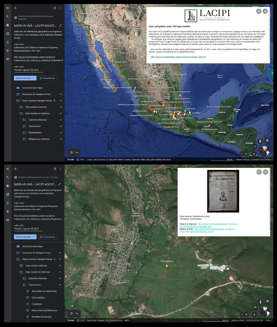
In order to offer a complete online access to the map, we display it on the present webpage by means of the Google My Maps tool, which yields optimal if somewhat limited consultation and edition options. For this reason we must present it in two parts: one dedicated to the news titles and another to all the other titles.
See the section “Alternative search” hereunder, which gives access to a KML archive that allows to upload the map to Google Earth, a viewer that enables the display of the VArroyo map and presents both the news and the non-news titles.
Note: it is convenient to consult the maps in full-screen mode following these links:
Map of the Vanegas Arroyo print shop location:
Map of the news titles:
Map of non-news titles:
Alternative search: Google Earth
The best display of this map can be obtained by uploading the KML archive that integrates all its data to Google Earth; this tool’s web and desktop versions will additionally give users the opportunity to edit and enrich it.
Instructions for the use of Google Earth Web Search:
- You must have a personal Google account
- Download the KML file and open the zip file.)
- Access https://www.google.com/earth/
- Log in with your Google Account
- On the left sidebar, select “Projects”
- Select “New project”
- Select “Import KLM from computer”
- Upload the archive named MAPA HV AVA - LACIPI AGOSTO 2021 - GEarth Web.kml
It is useful to click on “Map Style” and select the “Clean” option, for this will enable the reading of the headers of each of the printed sheets referred to on the map.
Notes
The team used Google Earth (Pro) to link the geographic coordinates with the printed items of the LACIPI database, through which we generated the KML file Archivo:MAPA_HV_AVA_-_LACIPI_AGOSTO_2021_-_GEarth_Web.zip which stands as the map viewer provided to be downloaded in either the web or desktop version of Google Earth.
The selection of the 152 broadsheets considered three items with geographical references to Spain and Italy; it is therefore advisable to manipulate the map viewer to keep the in view. The users can refer to the “Approximation for a possible classification” on the page concerning broadsheets of this website to consult the thematic classification followed when elaborating the map.
A previous version of the map viewer can still be accessed in Ptos_literartura-IVArroyo.kml. This version was made with 45 printed items around the year 2014 by the members of LACIPI in collaboration with Ivan Franch.
|
AVISO LEGAL · EQUIPO y COLABORADORES · CONTACTO HECHO EN MÉXICO © UNAM 2009 - 2024 |
|
|